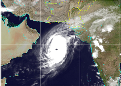
Advisories (34)
Advisory# 34 |
Issue Date: 16 May, 2021 12:15 PM |
Tropical Cyclone “TAUKTAE” in the Southeast Arabian Sea
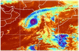
The Severe Cyclonic Storm “TAUKTAE” intensified into a Very Severe Cyclonic Storm (VSCS), moved further Northwestward at a speed of 15 Km during last 12 hours and. It now lay centered at 0800 PST of 16 May 2021 near latitude 15.3N and longitude 72.5E, at a distance of about 1210 km south-southeast of Karachi. Maximum sustained winds around the system centre are 100-120 Kmph gusting to 140 Kmph. The system is likely to move further northwestward and reach Indian Gujarat by 18th May morning.
Due to shift in TC course, prevailing environmental and meteorological conditions, dust/thunderstorm-rain with few moderate to heavy falls with gusty winds of 60-80 Kmph are likely to occur in Thatta, Sujawal, Badin, Tharparker, Mirpurkhas, Umerkot & Sanghar districts during 17- 19 May 2021. Karachi, Hyderabad, and Shaeed- Banzirabad, districts likely to experience hot/very hot weather with gusty winds and blowing dust during next two days. Sea Conditions will remain rough to very rough and fishermen are advised not to venture in the sea till 19 May 2021.

Issued By: Tropical Cyclone Warning Centre, Karachi
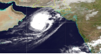
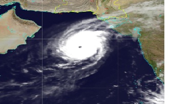
Advisory# 33 |
Issue Date: 15 May, 2021 10:00 PM |
Tropical Cyclone “TAUKTAE” in the Southeast Arabian Sea
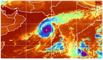
The Cyclonic Storm “TAUKTAE” intensified into a Severe Cyclonic Storm (SCS) has tracked Northwestward at a speed of 18 Km and lay centered at 2100 PST of 15 May 2021 near latitude 14.5N and longitude 72.8E, at a distance of about 1310 km south-southeast of Karachi. Maximum sustained winds around the system centre are 100-120 Kmph gusting to 140 Kmph. The system is likely to intensify further into a Very Severe Cyclonic Storm (VSCS) during next 18-24 hours and move further in northwest direction and reach Indian Gujarat by 18th May afternoon/evening.
Based on the existing meteorological conditions, dust/thunderstorm-rain with few moderate to heavy falls with gusty winds of 60-80 Kmph are likely to occur in Thatta, Sujawal, Badin, Tharparker, Mirpurkhas, Umerkot & Sanghar districts during 17- 20 May 2021. Dust/thunderstorm-rains with isolated moderate/heavy falls and gusty winds of 40-60 Kmph are also likely in Karachi, Hyderabad, Jamshoro and Shaeed- Banzirabad, during 18-20 May 2021. Sea Conditions will be rough to very rough and fishermen are advised not to venture in the sea during 16-20 May 2021.

Issued By: Tropical Cyclone Warning Centre, Karachi
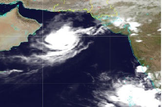
Advisory# 32 |
Issue Date: 15 May, 2021 02:53 PM |
Tropical Cyclone “TAUKTAE” in the Southeast Arabian Sea
The Depression over Southeast Arabian has intensified into a Cyclonic Storm “TAUKTAE” and lay centered at 0800 PST of 15 May 2021 near latitude 12.7N and longitude 72.3E, at a distance of about 1460 Km south-southeast of Karachi. Maximum sustained winds around the system centre are 70-90 Kmph gusting to 100 Kmph. The system is likely to intensify further into a Severe Cyclonic Storm (SCS) during next 12-18 hours and move in north-northwest direction and reach Indian Gujarat by 18th May morning.
According to present environmental conditions and under the influence of this system, widespread raindust/thunderstorm with few heavy to very heavy falls and gusty winds of 70-90 Kmph are likely to occur in Thatta, Badin, Thar, Mirpurkhas, Umerkot & Sanghar districts from 17 May to 20 May 2021. Raindust/thunderstorm with few heavy falls and gusty winds of 40-60 Kmph are also likely in Karachi, Hyderabad, Jamshoro, Shaeed Banzirabad, Sukkur, Larkana, Shikarpur, Jacobabad and Dadu during 18-20 May 2021. Sea Conditions will be rough to very rough and fishermen are advised not to venture in the sea during 16-20 May 2021.

Issued By: Tropical Cyclone Warning Centre, Karachi
Advisory# 31 |
Issue Date: 14 May, 2021 03:52 PM |
Tropical Cyclone Formation Alert- 03 in the Southeast Arabian Sea
Yesterday’s low-pressure area over Southeast Arabian Sea has rapidly intensified into a Depression (intense low-pressure area) and lay centered around latitude 11.0N and longitude 72.3E, at a distance of about 1640 km southeast of Karachi. The system is likely to intensify further into a Cyclonic Storm during next 18-24 hours and move in north-northwest direction.
PMD’s tropical Cyclone Warning Centre, Karachi is closely monitoring the system and will keep updating accordingly. Presently, none of Pakistan coastal area is under any threat. However, Fishermen of Sindh are advised to remain alert and avoid going into deep sea.

Issued By: Tropical Cyclone Warning Centre, Karachi
Advisory# 30 |
Issue Date: 13 May, 2021 04:55 PM |
Tropical Cyclone Formation Alert in the Southeast Arabian Sea
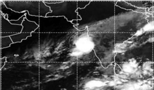
Spokesman of Met Office informed that a low-pressure area has formed over Southeast Arabian Sea and adjoining areas, at a distance of about 1440 km from Karachi. The system is likely to strengthen further into a Depression (strong low-pressure area) during next 36-48 hours and then into a Tropical Cyclone by 16th May and move in northwest direction.
PMD’s tropical Cyclone Warning Centre, Karachi is closely monitoring the system and updates will be issued accordingly. Presently, none of Pakistan coastal area is under any threat. However, Fishermen of Sindh are advised to remain alert and avoid going into deep sea from 14th May onwards.
Satellite imagery at 13 May, 1530 PST

Issued By: Tropical Cyclone Warning Centre, Karachi
Advisory# 29 |
Issue Date: 12 May, 2021 04:12 PM |
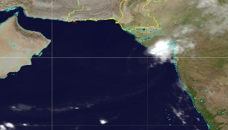
Tropical Cyclone Formation Alert in the East Arabian Sea
Spokesman of Met Office informed that there are strong convective clouds lying over the South/Southeast Arabian Sea which consequently may lead to formation of a low-pressure area over there by 14 May morning. Due to favourable environmental conditions the system is very likely to strengthen into a Tropical Cyclone by 16th May.
PMD’s tropical Cyclone Warning Centre, Karachi is closely monitoring the system and updates will be issued accordingly. Presently, none of Pakistan coastal area is under any threat. However, Fishermen of Sindh are advised to remain alert and avoid going into deep sea from 14th May onwards.
Satellite imagery at 1300 PST

Issued By: Tropical Cyclone Warning Centre, Karachi
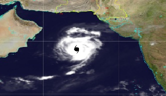
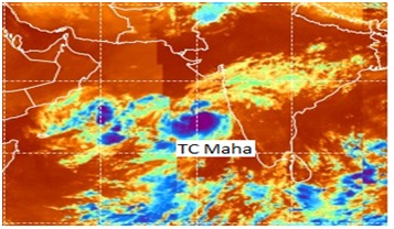
Advisory# 28 |
Issue Date: 7 November, 2019 04:36 PM |
[FINAL WARNING] Cyclonic Storm
FINAL WARNING
The Cyclonic Storm (CS) "MAHA" over east-central Arabian Sea has rapidly weakened into a depression and located this morning around Lat 19.8 N and Long 69.4 E, at a distance of about 600 km southeast of Karachi.
The fishermen now can go into deep sea, as the sea conditions turning to calm and normal. This is the final warning regarding TC-MAHA.
IR Satellite imagery at 0800 PST
Issued By: Tropical Cyclone Warning Centre, Karachi
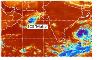
Advisory# 27 |
Issue Date: 6 November, 2019 10:27 PM |
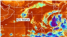
Severe Cyclonic Storm "MAHA" in Eastcentral Arabian Sea
The Very Severe Cyclonic Storm (VSCS) "MAHA" over east-central Arabian Sea has weakened into a Severe Cyclonic Storm (SCS) and tracked eastwards during last 12 hours. It is located at 2000 PST of 6th November 2019 around Lat 19.8 N and Long 68.3 E at a distance of about 570 km south-southeast of Karachi with maximum sustained surface winds 80-100 kmph TC-Maha is likely to weaken further into a cyclonic storm, continue tracking eastward and cross south Gujarat coast India by tomorrow.
There is no threat to Pakistan coastal area; however, fishermen of Sindh are advised not to venture in deep sea till tomorrow. The Tropical Cyclone Warning Center of PMD is regularly monitoring the intensity and track of this Tropical Cyclone.
The concerned authorities are requested to keep them abreast of the system updates through PMD website.
IR Satellite imagery at 2120 PST
Issued By: Tropical Cyclone Warning Centre, Karachi
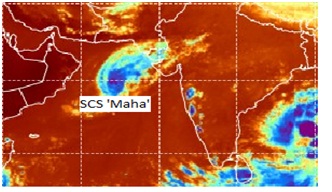
Advisory# 26 |
Issue Date: 6 November, 2019 11:09 AM |
Severe Cyclonic Storm MAHA in the Central Arabian Sea
The Very Severe Cyclonic Storm (ESCS) "MAHA" over central Arabian Sea has weakened into a Severe Cyclonic Storm (SCS) and tracked eastwards during last 12 hours. It is located at 0800 PST of 6thNovember 2019 around Lat 19.8 N and Long 66.7 E at a distance of about 555 km south of Karachi with maximum sustained surface winds of 100-120 kmph.TC-Maha is likely to weaken further into cyclonic storm by today evening and continue tracking eastward towards Indian Gujarat. There is no threat to Pakistan coastal area; however, fishermen of Sindh are advised not to venture in deep sea till tomorrow.
The Tropical Cyclone Warning Center of PMD is regularly monitoring the intensity and track of this Tropical Cyclone. The concerned authorities are requested to keep them abreast of the system updates through PMD website.
IR Satellite imagery at 0940 PST
Issued By: Tropical Cyclone Warning Centre, Karachi
Advisory# 25 |
Issue Date: 5 November, 2019 10:10 PM |
Very Severe Cyclonic Storm MAHA in the CentralArabian Sea
The Extremely Severe Cyclonic Storm (ESCS) "MAHA" over central Arabian Sea has weakened into a Very Severe Cyclonic Storm (VSCS) and tracked eastwards during last 12 hours. It is located at 2000 PST of 5thNovember 2019 around Lat 19.8 N and Long 64.1 E, at a distance of about 635 km southwest of Karachi with maximum sustained surface winds of 140-160 kmph gusting 180 kmph. TC-Maha is likely to weaken further and continue tracking eastward towards Indian Gujarat.
There is no threat to Pakistan coastal area; however, the fishermen are advised not to venture in deep sea till tomorrow. The Tropical Cyclone Warning Center of PMD is regularly monitoring the intensity and track of this Tropical Cyclone.
The concerned authorities are requested to keep them abreast of the system updates through PMD website.
IR Satellite imagery at 2000 PST
Issued By: Tropical Cyclone Warning Centre, Karachi
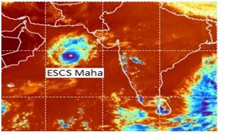
Advisory# 24 |
Issue Date: 5 November, 2019 11:04 AM |
Extremely Severe Cyclonic Storm MAHA in the Central Arabian Sea
The Extremely Severe Cyclonic Storm (ESCS) "MAHA" over the central Arabian Sea has tracked northwards during last 12 hours and slightly weakened. It is located at 0800 PST of 5th November 2019 around Lat 19.6 N and Long 63.7 E, at a distance of about 675 km southwest of Karachi with maximum sustained surface winds of 160-180 kmph gusting 200 kmph. TC-Maha is likely to weaken gradually and track eastward towards Indian Gujarat.
There is no threat to Pakistan coastal area; however, fishermen are advised not to venture in deep sea till 6 Nov. The Tropical Cyclone Warning Center of PMD is regularly monitoring the intensity and track of this Tropical Cyclone. The concerned authorities are requested to keep them abreast of the system updates through PMD website.
IR Satellite imagery at 0840 PST
Issued By: Tropical Cyclone Warning Centre, Karachi
Advisory# 23 |
Issue Date: 4 November, 2019 09:34 PM |
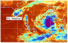
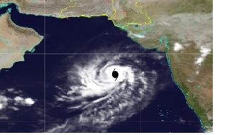
Extremely Severe Cyclonic Storm MAHA in the Central Arabian Sea
An Extremely Severe Cyclonic Storm (ESCS) "MAHA" over central Arabian Sea has tracked north-northwestwards during last 12 hours and located at 2000 PST of 4th November 2019 around Lat 19.0 N and Long 64.3 E at a distance of about 705 kmsouthwest of Karachi with maximum sustained surface winds of 170-190 kmph gusting 210 kmph. TC-Maha is likely to track northwards during next 12 hours and then recurve in east-northeast direction towards Indian Gujarat.
Currently, there is no threat to Pakistan coastal area, however, fishermen are advised not to venture in deep sea till 6 Nov. The Tropical Cyclone Warning Center of PMD is regularly monitoring the intensity and track of this Tropical Cyclone
The concerned authorities are requested to keep them abreast of the system updates through PMD website.
IR Satellite imagery at 1940 PST
Issued By: Tropical Cyclone Warning Centre, Karachi
Advisory# 22 |
Issue Date: 4 November, 2019 12:13 PM |
Extremely Very Severe Cyclonic Storm MAHA in the CentralArabian Sea
The Very Severe Cyclonic Storm (VSCS) "MAHA" over the eastcentral Arabian Sea has tracked northwestwards during last 12 hours and intensified as an Extremely Severe Cyclonic Storm (ESCS) located at 0800 PST of 4th November 2019 around Lat 18.2 N and Long 64.8 E at a distance of about 770 km south of Karachi with maximum sustained surface winds of 160-180 kmph gusting 200 kmph. TC-Maha is likely to track further west/northwestwards during next 24 hours and then recurve in east-northeast direction towards Indian Gujarat.
Currently, there is no threat to Pakistan coastal area, however, fishermen are advised to avoid going into deep sea till 6 Nov.
Tropical Cyclone Warning Center of PMD is regularly monitoring the intensity and track of this Tropical Cyclone.
The concerned authorities are requested to keep them abreast of the system updates through PMD website.
IR Satellite imagery at 1000 PST
Issued By: Tropical Cyclone Warning Centre, Karachi
Advisory# 21 |
Issue Date: 3 November, 2019 09:27 PM |
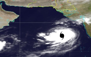
Very Severe Cyclonic Storm MAHA in the Eastcentral Arabian Sea
The Very Severe Cyclonic Storm (VSCS) "MAHA" over the eastcentral Arabian Sea has tracked further northwestwards during last 12 hours and located at 2000 PST of 3rd November 2019 around Lat 17.8 N and Long 65.4 E at a distance of about 797 km south-southwest of Karachi with maximum sustained surface winds of 130-150 kmph.
TC-Maha is likely to track further west/northwestwards during next 24 hours and then recurve in east-northeast direction towards Indian Gujarat.
Currently, there is no threat to Pakistan coastal area however, fishermen are advised to avoid going into deep sea from tomorrow.
The Tropical Cyclone Warning Center of PMD is regularly monitoring the intensity and track of this Tropical Cyclone.
The concerned authorities are requested to keep them abreast of the system updates through PMD website.
IR Satellite imagery at 2000 PST
Issued By: Tropical Cyclone Warning Centre, Karachi
Advisory# 20 |
Issue Date: 3 November, 2019 10:35 AM |
Very Severe Cyclonic Storm MAHA in the Eastcentral Arabian Sea
The Severe Cyclonic Storm "MAHA" over the eastcentral Arabian Sea has intensified into a Very Severe Cyclonic Storm (VSCS), moved further northwestwards during last 12 hours and located at 0800 PST of 3rd November 2019 around Lat 17.7 N and Long 66.1 E, at a distance of about 794 km south of Karachi with maximum sustained surface winds of 120-140 kmph.
TC-Maha is likely to track further west/northwestwards during next 24 hours and then recurve in east-northeast direction towards Indian Gujarat.
Currently, there is no threat to Pakistan coastal area. However, fishermen are advised to remain careful and avoid going into deep sea from Monday. The Tropical Cyclone Warning Center of PMD is regularly monitoring the intensity and track of this Tropical Cyclone.
The concerned authorities are requested to keep them abreast of the system updates through PMD website.
IR Satellite imagery at 0800 PST
Issued By: Tropical Cyclone Warning Centre, Karachi
Advisory# 19 |
Issue Date: 2 November, 2019 10:07 PM |
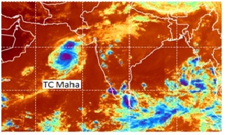
Cyclonic Storm MAHA in the South East Central Arabian Sea
The Severe Cyclonic Storm "MAHA" over the eastcentral Arabian Sea has moved northwestwards during last 12 hours and located at 2000 PST of 2nd November 2019 around Lat 17.2 N and Long 67.3 E at a distance of about 845 km south of Karachi with maximum sustained surface winds of 100-120 kmph. TC-Maha is likely to intensify into a Very Severe Cyclonic Storm (VSCS) by tomorrow and track further west/northwestwards for next two days and then recurve northeast towards Indian Gujarat.
Currently, there is no threat to Pakistan coastal area. However, fishermen are advised to remain careful and avoid into deep sea from Monday. The Tropical Cyclone Warning Center of PMD is regularly monitoring the intensity and track of this Tropical Cyclone.
The concerned authorities are requested to keep them abreast of the system updates through PMD website.
IR Satellite imagery at 0800 PST
Issued By: Tropical Cyclone Warning Centre, Karachi
Advisory# 18 |
Issue Date: 2 November, 2019 12:06 PM |
Cyclonic Storm MAHA in the South East Central Arabian Sea
The Severe Cyclonic Storm "MAHA" over the eastcentral Arabian Sea has moved northwestwards during last 12 hours and located at 0800 PST of 2nd November 2019 around Lat 16.4°N and Long 68.3°E at a distance of about 940 km southeast of Karachi with maximum sustained surface winds of 90-110 kmph. TC-Maha is likely to intensify into a Very Severe Cyclonic Storm (VSCS) during next 12 hours, track further west/northwestwards for next two days and then recurve northeast towards Indian Gujarat.
Currently, there is no threat to Pakistan coastal area. However, fishermen are advised to remain careful and avoid into deep sea from Monday.
The Tropical Cyclone Warning Center of PMD is regularly monitoring the intensity and track of this Tropical Cyclone.
The concerned authorities are requested to keep them abreast of the system updates through PMD website.
IR Satellite imagery at 0900 PST
Issued By: Tropical Cyclone Warning Centre, Karachi
Advisory# 17 |
Issue Date: 2 November, 2019 11:48 AM |
Cyclonic Storm MAHA in the South East Central Arabian Sea
The Severe Cyclonic Storm "MAHA" over the eastcentral Arabian Sea has moved northwestwards during last 12 hours and located at 2000 PST of 1st November 2019 around Lat 16.0°N and Long 69.0°E at a distance of about 1000 km southeast of Karachi with maximum sustained surface winds of 90-110 kmph. TC-Maha is likely to intensify into a Very Severe Cyclonic Storm (VSCS) during next 24 hours, track further west/northwestwards for next three days and then recurve towards northeast.
Currently, there is no threat to Pakistan coastal area. The Tropical Cyclone Warning Center of PMD is regularly monitoring the intensity and track of this Tropical Cyclone.
The concerned authorities are requested to keep them abreast of the system updates through PMD website.
IR Satellite imagery at 2020 PST
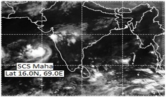
Issued By: Tropical Cyclone Warning Centre, Karachi
Advisory# 16 |
Issue Date: 1 November, 2019 10:53 AM |
Severe Cyclonic Storm MAHA in the Eastcentral Arabian Sea
The Severe Cyclonic Storm "MAHA" over the eastcentral Arabian Sea has moved north-northwestwards during last 12 hours and located at 0800 PST of 1st November 2019 around Lat 15.4 N and Long 71.5 E, at a distance of about 1140 km southeast of Karachi with maximum sustained surface winds of 90-110 kmph. TC-Maha is likely to track further northwestwards and intensify into a Very Severe Cyclonic Storm (VSCS) during next 24 hours.
Currently there is no threat to Pakistan coastal area. The Tropical Cyclone Warning Center of PMD is regularly monitoring the intensity and track of this Tropical Cyclone.
The concerned authorities are requested to keep them abreast of the system updates through PMD website.
IR Satellite imagery at 0940 PST
Issued By: Tropical Cyclone Warning Centre, Karachi
Advisory# 15 |
Issue Date: 31 October, 2019 11:22 PM |
Cyclonic Storm MAHA in the East central Arabian Sea
The cyclonic storm 'MAHA' over the east central Arabian Sea has moved north-northwestwards during last 12 hours and located at 2000 PST of 31st October, 2019 around Lat 13.3N and Long 72.5E, at a distance of about 1400km southeast of Karachi. TC-Maha is likely to track northwestwards and intensify into a Severe Cyclonic Storm (SCS) during next 24 hours.
Currently there is no threat to Pakistan coastal area. The Tropical Cyclone Warning Center of PMD is regularly monitoring the intensity and track of this Tropical Cyclone.
The concerned authorities are requested to keep them abreast of the system updates through PMD website.
Issued By: Tropical Cyclone Warning Centre, Karachi
Advisory# 14 |
Issue Date: 31 October, 2019 09:39 PM |
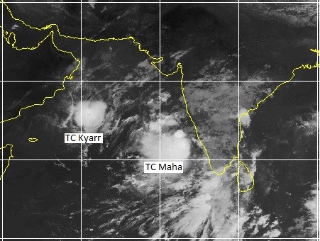
Cyclonic Storm 'KYARR' in Westcentral Arabian Sea
Cyclonic Storm has tracked more southwest-wards during last 12 hours and lay centered at 2000 PST of 31 Oct 2019 near Lat17.1°N and Long 59.5°E with maximum sustained surface winds of 65-80 kmph. It is now at about 1160 km southwest of Karachi, 955 km south of Gwadar and 345 km southeast of Masirah-Island (Oman). Kyarr is likely to weaken further and dissipate as a depression over waters during next 24 hours.
This is the last advisory of this system.
IR Satellite imagery of TCs at 2020 PST, 31 October 2019
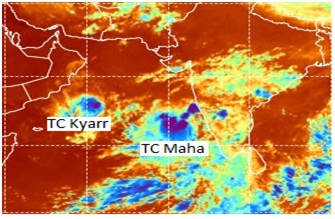
Issued By: Tropical Cyclone Warning Centre, Karachi
Advisory# 13 |
Issue Date: 31 October, 2019 01:24 PM |
Cyclonic Storm MAHA in the South East Central Arabian Sea
The cyclonic storm MAHA over the southeast Arabian Sea has moved north-northwestwards during last 12 hours and located at 0800 PST 0f 31st October, 2019 around Lat 11.5°N and Long 72.9°E. TC-Maha is likely to track northwestwards and intensify more as a Severe Cyclonic Storm (SCS) during next 24hours.
The system is too far away from Pakistan coast, hence has no threat at present.
The Tropical Cyclone Warning Center of PMD is regularly monitoring the intensity and track of this Tropical Cyclone. The concerned authorities are requested to keep them abreast of the system updates through PMD website.
Satellite imagery of MAHA at 1000 PST 31 Oct 2019

Issued By: Tropical Cyclone Warning Centre, Karachi
Advisory# 12 |
Issue Date: 31 October, 2019 01:22 PM |
Severe Cyclonic Storm KYARR in Central Arabian Sea
The Severe Cyclonic Storm has weakened into a Cyclonic Storm and tracked more southwest-wards during last 12 hours and lay centered at 0800 PST of 31 Oct 2019 near Lat18.0°N and Long 60.3°E with maximum sustained surface winds of 70-90 kmph. It is now at about 1030 km southwest of Karachi, 826 km south of Gwadar and 310 km southeast of Masirah Island (Oman). Kyarr is likely to weaken further into a depression and move to Gulf of Aden during next 24 hours.
Fishermen are advised not to venture in open sea till today's evening.
IR Satellite imagery at 1000 PST, 31 October 2019
Issued By: Tropical Cyclone Warning Centre, Karachi
Advisory# 11 |
Issue Date: 30 October, 2019 11:14 PM |
Cyclonic Storm MAHA in the South East Central Arabian Sea
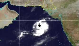
Spokesman of Met Office informed that the deep depression previously located over the South-east Arabian Sea has rapidly intensified into a Cyclonic Storm 'MAHA' during last six hours and lay centered at 2000 PST of 30 October 2019 around Lat 9.0°N and Long 74.1°E. TC-Maha is likely to track northwest wards and intensify more as severe cyclonic storm (SCS) during next 24 hours.
Tropical Cyclone Warning Center of PMD is regularly monitoring the intensity and track of this Tropical Cyclone. The concerned authorities are requested to keep them abreast of the system updates through PMD website.
Satellite imagery at 1500 PST
Issued By: Tropical Cyclone Warning Centre, Karachi
Advisory# 10 |
Issue Date: 30 October, 2019 11:12 PM |
Very Severe Cyclonic Storm 'KYARR' in Central Arabian Sea
The very Severe Cyclonic Storm has tracked more southwest wards during last 12 hours and lay centered at 2000 PST of 30 Oct 2019 near Lat18.7°N and Long 61.1°E with maximum sustained surface winds of 120-140 kmph. It is now at about 910 km southwest of Karachi, 722 km south of Gwadar and 317 km southeast of Masirah Island (Oman). Kyarr is likely to weaken further into a Severe Cyclonic Storm (SCS) and move to Gulf of Aden during next 24 hours.
There is no direct threat to Pakistan coast; however light/moderate rain-TS is expected at a few places along Makran Coast during next two days.
Fishermen are advised not to venture in open sea till 31 October.
IR Satellite imagery at 2000 PST, 30 October 2019
Issued By: Tropical Cyclone Warning Centre, Karachi
Advisory# 9 |
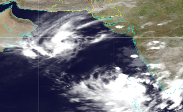
Issue Date: 30 October, 2019 01:09 PM |
Very Severe Cyclonic Storm 'KYARR' in Centeral Arabian Sea
Extremely Severe Cyclonic Storm (ESCS) over westcentral Arabian Sea has weaken into a Very Severe Cyclonic Storm and tracked in west/northwest direction during last 12 hours and lay centered at 0800 PST of 30 Oct 2019 near Lat19.6°N and Long 62.0°E with maximum sustained surface winds of 160-180 kmph. It is now at about 790 km southwest of Karachi, 645 km south of Gwadar and 365 km southeast of Masirah Island (Oman). Kyarr is likely to divert southwestward, weaken gradually and track towards Gulf of Aden.
There is no direct threat to Pakistan coast; however, due to exceptionally strong winds around the system's centre and roughness in sea, there is a risk of water inflow in low-lying islands at the time of high tides, (11:31am 2.97m and 00:30 am 3.1m). Light/moderate rain-TS is expected at a few places in lower Sindh and along Makran Coast during Thursday-Friday.
Fishermen are advised not to venture in open sea till 31 Oct.
Tropical Cyclone Warning Center of PMD is regularly monitoring the intensity and track of this Tropical Cyclone.The concerned authorities are requested to keep them abreast of the system updates through PMD website.
Issued By: Tropical Cyclone Warning Centre, Karachi
Advisory# 8 |
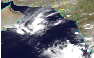
Issue Date: 29 October, 2019 09:15 PM |
Extremely Severe Cyclonic Storm 'KYARR' in Central Arabian Sea
The Super Cyclonic Storm over central Arabian Sea has tracked further northwestward during last 12 hours and now lay centered at 2000 PST near Lat 19.5°N and Long 62.9°E with maximum sustained surface winds of 180-200 kmph, at about 720 km southwest of Karachi, 625 km of Gwadar and about 970 km northeast of Salalah (Oman). TC-Kyarr is likely to move further westwards till tomorrow and then turn southwestward and weaken to very severe cyclonic storm during next 18 hours.
There is no direct threat to any coastal area of Pakistan; however, due to exceptionally strong winds around the system's centre and roughness in sea, low-lying islands may suffer by water intrusion due to high tides. Also, scattered DS/TS-rain is expected in lower Sindh and along Makran Coast during Wednesday-Friday. Fishermen are advised not to venture in open sea till 31 Oct.
Tropical Cyclone Warning Center of PMD is regularly monitoring the intensity and track of this Tropical Cyclone. The concerned authorities are requested to keep them abreast of the system updates through PMD website.
IR Satellite imagery at 2000 PST, 29 October 2019
Issued By: Tropical Cyclone Warning Centre, Karachi
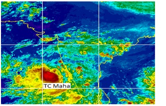
Advisory# 7 |
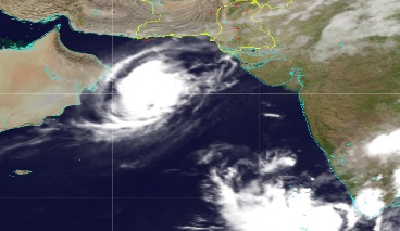
Issue Date: 29 October, 2019 11:00 AM |
Super Cyclonic Storm 'KYARR' in Central Arabian Sea
The Super Cyclonic Storm over central Arabian Sea has tracked northwestward during last 12 hours and now lay centered at 0800 PST near Lat 19.2°N and Long 63.4°E with maximum sustained surface winds of 230-240 kmph gusting 250kmph, at about 730 km southwest of Karachi, 665 km of Gwadar and 1012 km northeast of Salalah (Oman). Kyarr is likely to move further northwestwards till tomorrow and then turn southwestward.
There is no direct threat to any coastal area of Pakistan; however, due to exceptionally strong winds around the system's centre and roughness in sea, low-lying islands may suffer by water intrusion due to high tides.Also, scattered DS/TS-rain is expected in lower Sindh and along Makran Coast during Wednesday-Friday. Fishermen are advised not to venture in open sea till 31 Oct.
Tropical Cyclone Warning Center of PMD is regularly monitoring the intensity and track of this Tropical Cyclone.The concerned authorities are requested to keep them abreast of the system updates through PMD website.
IR Satellite imagery at 1000 PST, 29 October 2019
Issued By: Tropical Cyclone Warning Centre, Karachi
Advisory# 6 |
Issue Date: 28 October, 2019 09:15 PM |
Super Cyclonic Storm 'KYARR' in Central Arabian Sea
The Super Cyclonic Storm over Eastcentral Arabian Sea has tracked northwestward during last 12 hours and now lay centered near Lat 18.6°N and Long 64.2°E with maximum sustained surface winds of 230-240 kmph gusting 265 kmph, at about 750 km southwest of Karachi and 1080 km northeast of Salalah (Oman). Kyarr is likely to move further northwestwards during next 36 hours and then turn southwestward.
There is no direct threat to any coastal area of Pakistan; however, due to exceptionally strong winds around the system's centre and roughness in sea, low-lying islands may suffer by water intrusion due to high tides. Also, scattered DS/TS-rain is expected in lower Sindh and along Makran Coast during Wednesday-Friday. Fishermen are advised not to venture in open sea till 31 Oct.
Tropical Cyclone Warning Center of PMD is regularly monitoring the intensity and track of this Tropical Cyclone. The concerned authorities are requested to keep them abreast of the system updates through PMD website.
IR Satellite imagery at 2000 PST, 28 October 2019
Issued By: Tropical Cyclone Warning Centre, Karachi
Advisory# 5 |
Issue Date: 28 October, 2019 01:06 PM |
Super Cyclonic Storm 'KYARR' in the Central Arabian Sea
The Super Cyclonic Storm over Eastcentral Arabian Sea has moved further west-northwestward during last 12 hours and now lay centered at 0800 PST of 28th October, 2019 near Lat 18.3°N and Long 65.2°E with maximum sustained surface winds of 230-240 kmph gusting 265 kmph, at about 745 km southwest of Karachi and 1180 km east of Salalah (Oman). The Super Storm Kyarr is likely to move further northwestwards towards Oman coast during next few days. Currently, none of the Pakistan coastal area is under direct threat from this system. However, under its influence scattered DS/TS-rain is expected in lower Sindh and along Makran Coast during Wednesday-Friday. Fishermen are advised not to venture in deep sea from today.
Tropical Cyclone Warning Center of PMD is regularly monitoring the intensity and track of this Tropical Cyclone.
The concerned authorities are requested to keep them abreast of the system updates through PMD website.
IR Satellite imagery at 2000 PST, 28 October 2019
Issued By: Tropical Cyclone Warning Centre, Karachi
Advisory# 4 |
Issue Date: 27 October, 2019 09:19 PM |
Super Cyclonic Storm in the East Central Arabian Sea
The Super Cyclonic Storm over Eastcentral Arabian Sea has moved west-northwestward during last 12 hours and now lay centered at 2000 PST of 27th October, 2019 near Lat 17.6°N and Long 66.5°E with maximum sustained surface winds of 230-240 kmh gusting 260 kmh, at about 800 km south of Karachi and 1300 km east of Salalah (Oman). The Super Storm Kyarr is likely to move further northwestwards towards Oman coast during next few days. Currently, none of the Pakistan coastal area is under direct threat from this system. However, under its influence scattered DS/TS-rain is expected in lower Sindh and along Makran Coast during Monday-Wednesday. Fishermen are advised to remain alert and not to venture in deep sea from Monday.
Tropical Cyclone Warning Center of PMD is regularly monitoring the intensity and track of this Tropical Cyclone.
The concerned authorities are requested to keep them abreast of the system updates through PMD website.
IR Satellite imagery at 2000 PST, 27 October 2019
Issued By: Tropical Cyclone Warning Centre, Karachi
Advisory# 3 |
Issue Date: 27 October, 2019 11:52 AM |
Super Cyclonic Storm in the East Central Arabian Sea
The Very Severe Cyclonic Storm (VSCS) 'Kyarre' over eastcentral Arabian Sea has very rapidly intensified into a Super Cyclonic Storm and moved west-northwestward during last 12 hours. The system lay centered at 0800 PST of 27th October, 2019 near Lat 17.1°N and Long67.8°E with maximum sustained surface winds of 230-240kmh gusting 260kmh, at about 850 km south of Karachi and 1500 km east of Salalah (Oman). The TC-Kyarr is likely to move further northwestwards towards Oman coast. Currently, none of the Pakistan coastal area is under direct threat from this system. However, under its influence scattered DS/TS-rain is expected in lower Sindh and along Makran Coast during Monday-Wednesday. Fishermen are advised to remain alert and not to venture in deep sea from Monday.
Tropical Cyclone Warning Center of PMD is regularly monitoring the intensity and track of this Tropical Cyclone.
The concerned authorities are requested to keep them abreast of the system updates through PMD website.
IR Satellite imagery at 1100 PST on 27 October 2019
Issued By: Tropical Cyclone Warning Centre, Karachi
Advisory# 2 |
Issue Date: 26 October, 2019 06:00 AM |
Very Severe Cyclonic Storm in the East Central Arabian Sea
The Cyclonic Storm 'Kyarr' over the eastcentral Arabian Sea has rapidly intensified into a Very Severe Cyclonic Storm (VSCS) and moved west-northwestward during last 12 hours. The system lay centered at 0830 PST of 26th October, 2019 near latitude 16.8°N and longitude 70.5°E about 950 km southeast of Karachi and 1780 km east-southeast of Salalah (Oman). The TCKyarr is likely to move west-northwestwards towards Oman coast and intensify further into an extremely severe cyclonic storm during next 24 hours. Currently none of the Pakistan coastal area is under direct threat from this system. However, under the influence of this system scattered DS/TS-rain is expected in lower Sindh and along Makran Coast during 28-30 October, 2019. Fishermen are advised to remain alert and not to venture in deep sea from Monday.
Tropical Cyclone Warning Center of PMD is regularly monitoring the intensity and track of this Tropical Cyclone
The concerned authorities are requested to keep them abreast of the system updates through PMD website.
IR Satellite imagery at 1000 PST on 26 October 2019
Issued By: Tropical Cyclone Warning Centre, Karachi
Advisory# 1 |
Issue Date: 25 October, 2019 06:36 AM |
Tropical Cyclone in the East Central Arabian Sea
Spokesman of Met Office informed that the Depression over the eastcentral Arabian Sea has intensified into a Cyclonic storm 'KYARRE' and lay centred at 1000pst of 25 October 2019 around Lat 16.0°N and Long 71.3°E, about 1050 km Southeast of Karachi. It is likely to intensify further into a Severe Tropical Cyclone and move in west/northwest direction to Oman coast and.
None of Pakistan coastal area is under any threat from this system.
However, Fishermen are advised to remain alert and avoid going into deep sea.
IR Satellite imagery at 0930 PST